|

The terrain of Scotland is predominantly mountainous but may be
divided into three distinct regions, from north to south: the
Highlands, the Central Lowlands, and the Southern Uplands. More
than one-half of the land in Scotland is occupied by the
Highlands, the most rugged region on the island of Great Britain
and the least densely inhabited part of Scotland. The Highlands
contain two parallel mountain chains that run roughly northeast
to southwest. The rocky summits of the Highlands were carved by
ancient glaciers and centuries of rain. Broken by deep ravines
and valleys, the region is noted for its scenic grandeur.
Precipitous cliffs, moorland plateaus, mountain lakes, sea
lochs, swift-flowing streams, and dense thickets are common to
the Highlands.
Dividing the parallel mountain ranges of the Highlands is a
depression, or fault line, known as the Glen More, or the Great
Glen. This depression extends southwest from Moray Firth on the
eastern coast to Loch Linnhe on the western coast. Within the
Great Glen is a chain of narrow lakes, or lochs, including Loch
Ness. These natural lochs are linked by a series of artificial
channels and together form the Caledonian Canal. Small craft can
use this canal to sail through the Great Glen from coast to
coast. To the northwest of the Great Glen lie heavily eroded
peaks with fairly uniform elevations ranging from about 600 to
900 m (about 2,000 to 3,000 ft). Between the peaks are numerous
valleys, known as glens, carved by glaciers. In the Highlands
southeast of the Great Glen the topography is varied and
spectacular. This region is traversed by the Grampian Mountains,
the principal mountain system of Scotland. The highest peak of
the Grampians is Ben Nevis (1,343 m/4,406 ft), the highest
summit in the United Kingdom.
To the south of the Highlands
lie the Central Lowlands, a low-lying belt of fertile valleys
with an average elevation of 150 m (500 ft). Rich soils and most
of the countrys coal deposits are found in the Lowlands. This
region, which comprises just one-tenth of Scotlands surface
area, is home to Scotlands leading industries and cities and
the majority of the countrys population. Several chains of
hills cross the Lowlands, including the Ochil and Sidlaw hills,
as do several important rivers, notably the Clyde, Forth, and
Tay.
The terrain of the Southern
Uplands, a region less elevated and rugged than the Highlands,
consists largely of a moorland plateau traversed by rolling
valleys and broken by mountainous outcroppings. Only a few
summits in the Southern Uplands exceed 760 m (2,500 ft) in
elevation, the highest being Merrick (843 m/2,765 ft) in the
southwest. The Cheviot Hills adjoin the Southern Uplands region
along the boundary with England.
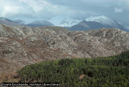
Scottish Highlands
More than half of the surface of Scotland is occupied by the
Scottish Highlands, the most rugged region in Great Britain.
They consist of parallel mountain chains with a general
northeast-to-southwest trend, broken by deep ravines and
valleys.
Hutchison Library/Gérard
Microsoft ® Encarta ® 2006. © 1993-2005 Microsoft
Corporation. All rights reserved.
|